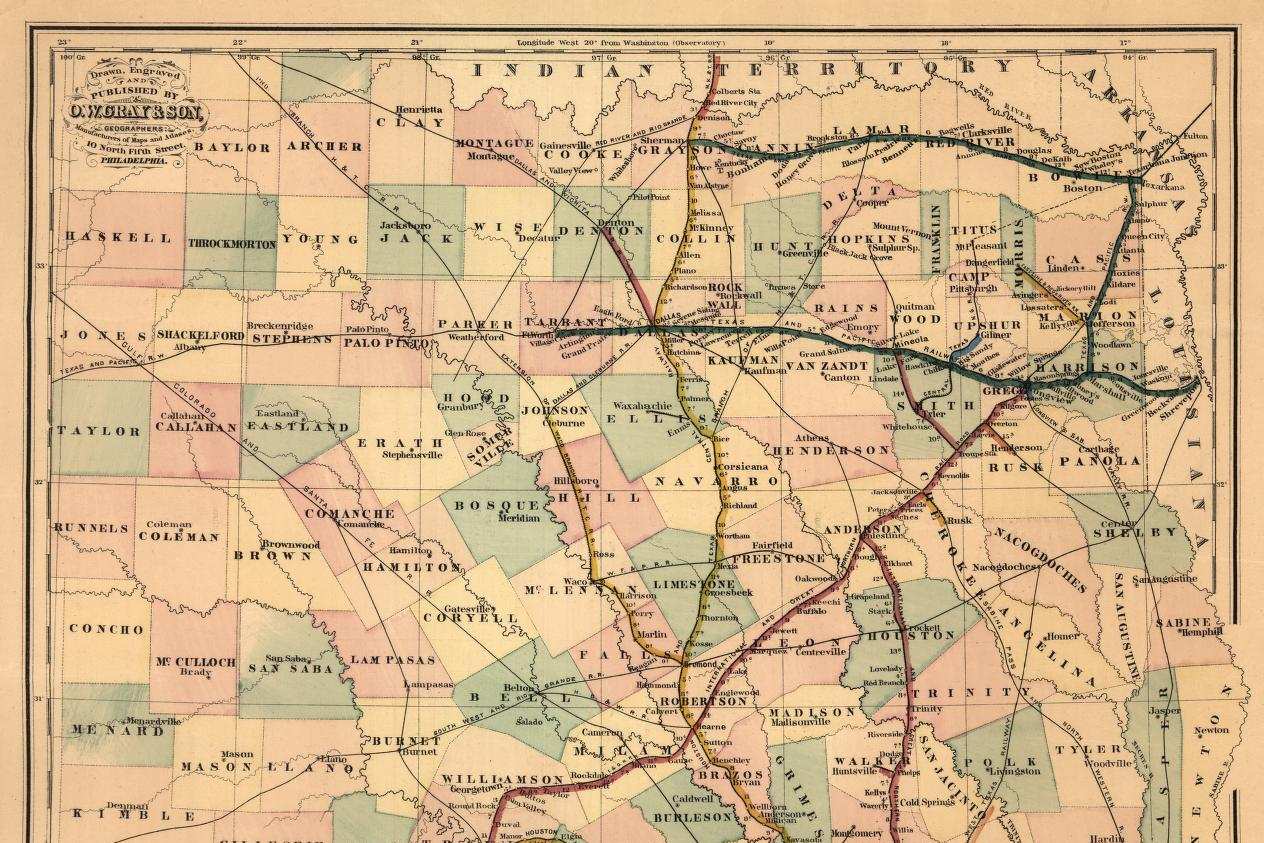
The sheet I hold is a full size print of Gray’s Railroad Map of Texas, copyrighted in 1877 by O.W. Gray and Son and catalogued by the Library of Congress as a hand colored map about 67 by 41 centimeters.1 It is the kind of object a traveler or a land buyer would fold into a coat. Under the title, in smaller capitals, the publisher promises that it was specially prepared from official sources.2
Look at the legend before the counties. Completed railroad lines, it says, are indicated by colors, and eighteen roads follow with a band of color beside each.2 Then look west of Fort Worth. A line labeled Texas and Pacific runs out through Weatherford, Palo Pinto, Breckenridge and Albany into Jones County, and it is drawn in plain black, outside the colors the legend reserves for finished track. So is a line marked Gulf, Colorado and Santa Fe cutting northwest through Comanche.2 The map is careful. It never says those roads exist. It simply puts them on the paper at the same weight as a county line, and a buyer in Philadelphia or Galveston looking at Shackelford County would see a railroad crossing it.
That is an argument, made in ink by a firm that sold maps, and I have no quarrel with it. The harder case is the map that claims no argument at all.
What the county map was drawn to settle
Gray does not say which official sources he used. The most official map of any Texas county in 1877 was the one kept by the General Land Office. The office was created by the First Congress of the Republic on December 22, 1836, and its commissioner opened for business in Houston the following October, charged by law with everything touching the public lands.3 By the Handbook’s account, every grant, patent and survey by which Texas disposed of its public domain is on file there, and each is represented, by metes and bounds, on the original grantee map of its county.3
The Portal to Texas History holds a collection of these county maps, added in 2010, and its description is the best short statement of their purpose I know.45 They are cadastral maps, meaning maps of ownership, showing the original surveys in a county, usually made by virtue of a land grant. As land was patented, more surveys were drawn in, and successive versions of a county’s map record those changes.5 Most were compiled and drawn by the office’s own draftsmen, most are manuscripts, and the usual scale is one inch to 4,000 varas. The office hired its own draftsmen, the description says, because the maps sent in by county and district surveyors were generally poor.5 One of those draftsmen, from 1887 to 1891, was William Sydney Porter, later known as O. Henry.3
So hold a land office county map next to Gray’s and ask the same question of it: what does it want the reader to believe? The answer is that the county is fully accounted for. Every tract has a boundary, a number, an original grantee and a place on the sheet, and the gaps between tracts are the public domain the state still owns. As I read it, the sheet existed to keep two surveys from claiming the same ground and to show the office what remained to give away. It was compiled in Austin by a draftsman who, I suspect in most cases, had never seen the county.
That is also an argument, and a quieter one. A railroad map argues about the future. A land office map argues that paper and ground are the same thing. Its neat lines carry the authority of the state, and nothing on the sheet tells you which corner a surveyor actually marked in the field and which was worked out on paper to close a figure.
I hold a position here that some careful researchers reject. I trust the land office county map more than any commercial map of the same county and year, and I trust it precisely because its purpose was so narrow. It had no customer to please and no railroad to promote. When it is wrong, it is wrong in a way I can predict, because I know what it was trying to do. A researcher who prefers the commercial map would say, fairly, that Gray at least drew towns and roads that travelers used, while the land office map can show a county neatly parceled that nobody yet lived in. I accept the point and keep my preference. A biased record whose bias I know is more useful to me than a friendly one whose bias I have to guess.
Reading two versions against each other
The method follows from the purpose. A single county map shows the state of the land records at one moment. Two versions of the same county, drawn some years apart, show what was filed in between, and that difference is the most useful thing the maps offer a historian. A block of surveys that appears on the later sheet and not the earlier one was patented, or at least recorded, in the interval.
What the difference does not date is settlement. A survey reached Austin when a surveyor sent in his return and the office drew it, which might be years after a family built a house on the ground or years before anyone did. The railroad sections are the plainest case. The state made grants for internal improvements, including railroads, that the Handbook totals at more than 32 million acres, and those surveys take their place on the county maps with every other grant.3 On the sheet they show a grant being administered. They say nothing about a train.
Where this breaks is in my own reading. The early mistake I made, and would guard against in anyone, was to treat a blank on a county map as empty country. A blank means no survey had been recorded in Austin when the draftsman worked. The ground may have held a family squatting on it, a surveyor’s return still in the mail, or a claim rejected in the office and never drawn. The map cannot tell those apart, and it does not try.
There is also a limit I cannot fix from a desk. The collection on the Portal holds 926 items, and its description notes that the land office itself has posted far more maps on its own website, of which the Portal carries only a small portion.5 The originals remain with the land office; the Handbook’s survey of the state archives records that the land office archives stayed in that department rather than passing to the state library.6 The Texas State Library and Archives Commission is therefore the wrong reading room for these sheets, a fact worth knowing before a trip to Austin. The same caution about scans and originals runs through the entry on the Portal to Texas History.
The pairing of maps is the same discipline I apply to people. A man tracked through three records of a single delegate is a man seen by three offices with three purposes, and a county seen by the land office and by a map publisher is a county seen twice for different reasons. The registration lists of 1867 count men who came forward, and the county map counts tracts that were filed; both are silent about what never reached a clerk. A photograph raises the same issue in another form, as the essay on captions shows, and the whole run of record studies sits under the archives hub. The land grants of the period have their own essay on grants to railroads before 1876.
In writing the biography of Coke I used both kinds of map and believed neither alone. Gray’s sheet told me what informed men in 1877 expected the state to become. The land office sheet told me what the state had recorded as owned. So I use the commercial map for expectation, the land office map for recorded title, and I do not use either one to say where anyone lived.
References
-
Library of Congress, Geography and Map Division, Gray’s railroad map of Texas. ↩
-
O.W. Gray and Son, Gray’s railroad map of Texas, 1877 to 1878, full sheet image, Library of Congress, digitized map. ↩ ↩2 ↩3
-
Handbook of Texas Online, Texas State Historical Association, General Land Office. ↩ ↩2 ↩3 ↩4
-
The Portal to Texas History, University of North Texas Libraries, History of the Portal. ↩
-
The Portal to Texas History, University of North Texas Libraries, GLO Historic County Maps. ↩ ↩2 ↩3 ↩4
-
Handbook of Texas Online, Texas State Historical Association, Texas State Archives. ↩
